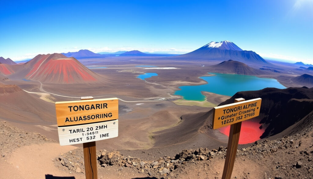
Tongariro Alpine Crossing Map: Distance, Time & Difficulty
Anyone who’s studied a map of Tongariro National Park before lacing up their boots already knows the challenge: the Tongariro Alpine Crossing isn’t a loop — it’s a point-to-point route across active volcanic terrain, with two separate trailheads and a weather pattern that can shift from calm to dangerous in under an hour. Getting the map right is just as important as getting your fitness right. This guide breaks down the distance, duration, start and finish points, costs, and seasonal considerations so you can plan with confidence.
Distance: 19.4 km (12 miles) one way ·
Duration: 6-8 hours ·
Highest point: 1,868 m (Red Crater) ·
Start point: Mangatepopo Road end ·
End point: Ketetahi Road end ·
Difficulty: Moderate to challenging
Quick snapshot
- The track is 19.4 km one way, according to the Department of Conservation (DOC) official track page
- Typical walking time is 7–8 hours per DOC guidance (Department of Conservation (DOC) official track page)
- Highest point is Red Crater at 1,868 m, per Tongariro Alpine Crossing overview
- Exact stair count may shift with trail maintenance, as noted by Tongariro Alpine Crossing business directory
- Shuttle costs vary by operator and season, per the business directory (Tongariro Alpine Crossing business directory)
- Summer (Dec–Feb) offers the most stable conditions, per DOC seasonal advice (Tongariro Crossing shuttle operator)
- Ketetahi car park is closed in winter and reopens October 24, according to Tongariro Crossing shuttle operator
- Download the official Tongariro Alpine Crossing map PDF before you go
- Book a shuttle in advance — morning departures start as early as 5:45 am, per The Alpine Centre schedule
Six key numbers, one pattern: the crossing demands preparation across distance, elevation, and time because every variable compounds on the others.
| Label | Value |
|---|---|
| Length | 19.4 km |
| Time | 6-8 hours |
| Highest point | 1,868 m |
| Start elevation | 1,120 m |
| End elevation | 760 m |
| Stairs count | ≈2,300 steps |
How long does it take to walk the Tongariro Alpine Crossing?
Average completion times
- Most walkers finish in 7–8 hours, according to the Department of Conservation (DOC) official track page
- The total distance is 19.4 km one way, confirmed by DOC published data
- Fast hikers can complete it in under 6 hours; groups with frequent stops may take 9 hours, as noted by Tongariro Alpine Crossing guide
Factors affecting duration
- Fitness level and pack weight directly influence pace, per DOC terrain notes
- Weather conditions — especially wind and rain — can add 30–60 minutes, according to the Tongariro Alpine Crossing business directory
- Photo stops at the Emerald Lakes and Red Crater are common, extending total time, per the Tongariro Alpine Crossing highlights
- Download the official Tongariro Alpine Crossing map PDF from the official site.
- Book a shuttle in advance to ensure transport to the trailhead.
- Check the weather forecast and track conditions on the DOC website.
- Start early — aim to be on the trail by 7:00 am.
- Carry at least 2-3 litres of water and sufficient food.
A walker who starts at 7:00 am from Mangatepopo and moves at a steady pace will reach Ketetahi by 2:00–3:00 pm — but only if the weather holds. The real variable isn’t distance; it’s the alpine window.
The pattern: the crossing demands a clear plan because conditions change rapidly. Starting early and booking ahead are non‑negotiable.
What is the best time of year to do the Tongariro Crossing?
Seasonal weather patterns
- Summer (December–February) offers the most stable weather and longest daylight, according to DOC seasonal guidance
- Winter (June–August) brings ice, snow, and avalanche risk — alpine gear (ice axe, crampons) is mandatory, per DOC winter advisory
- Spring and autumn are unpredictable: clear mornings can turn to afternoon storms, as noted by the Tongariro Alpine Crossing weather notes
Peak season vs. off-season
- December–February sees the highest visitor numbers; shuttles run frequently, per The Alpine Centre schedule
- Shuttle services generally operate October through April, according to The Alpine Centre pricing page
- Winter shuttle services are limited — one operator notes Ketetahi car park is closed until October 24, per Tongariro Crossing operator
The pattern: summer delivers reliability but crowds; winter delivers solitude but requires alpine skills and gear. The trade-off is a matter of experience and risk tolerance.
How many stairs is the Tongariro Crossing?
Stair sections and elevation gain
- The crossing includes approximately 2,300 steps, concentrated on the Devil’s Staircase section, per DOC elevation profile data
- The climb from Mangatepopo (1,120 m) to Red Crater (1,868 m) involves a 748 m elevation gain over roughly 5 km, according to the Tongariro Alpine Crossing map PDF
- Steep ascents and descents on scree and volcanic rock add to the leg strain, as noted by the Tongariro Alpine Crossing difficulty overview
Comparison to other hikes
- The 2,300 steps are comparable to climbing a 200-metre building staircase, per DOC terrain comparison
- By contrast, the Ben Lomond Track near Queenstown has roughly 1,400 steps over a shorter distance, according to Queenstown to Christchurch Drive guide
The implication: the stair count is a key metric for pacing. Plan breaks accordingly.
Where does the Tongariro Alpine Crossing begin?
Mangatepopo Road trailhead
- Most walkers start at the Mangatepopo car park (elevation 1,120 m), according to the Tongariro Crossing shuttle guide
- Parking at Mangatepopo is restricted to a four-hour limit, per the Tongariro Alpine Crossing visitor guidance
- The official DOC visitor centre is at Whakapapa Village, State Highway 48, Mount Ruapehu, per DOC contact details
Ketetahi Road trailhead
- The track ends at the Ketetahi car park (elevation 760 m), which is the common pickup point for return transport, per The Alpine Centre shuttle info
- Ketetahi car park is privately operated and closed during winter, reopening October 24, according to Tongariro Crossing operator
Access via shuttle
- Visitors are strongly recommended not to park at either trailhead and instead use park-and-ride or shuttles from nearby townships, per the Tongariro Alpine Crossing visitor guidance
- Morning shuttle departures start as early as 5:45 am, with later runs in peak summer, according to The Alpine Centre schedule
- One operator offers a car park plus shuttle package at NZD 67 per person, per Tongariro Crossing shuttle pricing
The implication: the trailhead you choose determines your entire logistics chain. Start at Mangatepopo, finish at Ketetahi, and never leave a car at the wrong end.
How fit do you need to be for Tongariro Crossing?
Physical demands
- The crossing requires good aerobic fitness to sustain effort over 6–8 hours, according to DOC fitness advisory
- Steep ascents on the Devil’s Staircase and loose scree descents test leg strength and balance, per the Tongariro Alpine Crossing terrain notes
- The high altitude (1,868 m at Red Crater) can affect those unaccustomed to thinner air, as noted by DOC altitude information
Preparation tips
- Build up with 2–3 shorter hikes of 10–15 km with elevation gain before attempting the crossing, per the Tongariro Alpine Crossing preparation guide
- Pack light — a 5–7 kg daypack is recommended, according to the Tongariro Alpine Crossing map PDF
- Previous hiking experience is helpful but not mandatory if you’re in good condition, per DOC difficulty classification
The pattern: fitness is the foundation. Without it, the day becomes a survival test rather than an adventure.
How much does it cost to do Tongariro Crossing?
Permit and fees
- There is no fee for track access, though a donation to the Tongariro National Park is suggested, per DOC fee information
- Parking at Mangatepopo is free but first-come, first-served with a four-hour limit, according to Tongariro Crossing car park page
Shuttle costs
- Return transport from The Alpine Centre costs NZD 60 per adult and NZD 35 per child (October–April), per The Alpine Centre pricing
- A car park plus shuttle package from Tongariro Crossing costs NZD 67 per person, according to Tongariro Crossing shuttle options
- Another operator lists a parking and shuttle fee of NZD 60, per the Tongariro Crossing car park page
Gear rental expenses
- Winter gear rental (ice axe, crampons, boots) can add NZD 50–100, depending on the operator, per the Tongariro Alpine Crossing business directory
- Summer gear rental is minimal — most walkers need only boots and a rain jacket, according to the Tongariro Alpine Crossing gear guide
A walker who drives to Mangatepopo and parks beyond the four-hour limit risks a fine. The smart play: park at a shuttle base, pay for the ride, and avoid the headache altogether.
The implication: the upfront shuttle cost is offset by convenience and peace of mind.
How difficult is the Tongariro Alpine Crossing?
Grading and terrain
- DOC classifies the crossing as a challenging alpine day hike, not suitable for inexperienced walkers in poor conditions, per DOC difficulty rating
- The terrain includes steep climbs, loose scree, exposed ridges, and volcanic rock, as described by the Tongariro Alpine Crossing terrain summary
- Track maintenance varies — the DOC updates conditions on its official track page
Weather challenges
- Weather can change rapidly — clear skies can turn to snow, rain, or high winds within an hour, per DOC weather warning
- Winter conditions (June–August) require alpine gear and experience, according to DOC winter advisory
- The track is exposed for most of the route above the treeline, with no shelter, per the Tongariro Alpine Crossing safety notes
Safety considerations
- Check the weather forecast and track conditions before setting out, per DOC safety checklist
- Carry sufficient water (2–3 litres), food, and warm layers, as recommended by the Tongariro Alpine Crossing map PDF
- Inform someone of your plan and expected return time, per DOC safety guidance
- Mobile phone reception is limited — satellite communication is recommended for remote sections, according to the Tongariro Alpine Crossing safety advice
The pattern: respect the terrain. A prepared walker enjoys the view; an unprepared one courts danger.
Upsides
- World-class volcanic scenery — Emerald Lakes, Red Crater, Blue Lake
- Well-marked track with DOC signage throughout
- Shuttle services make logistics manageable without a second car
- Free track access with no permit required
Downsides
- Point-to-point route requires transport coordination at both ends
- Weather can turn dangerous with little warning
- Parking restrictions at both trailheads limit car access
- Winter access requires alpine gear and experience
Timeline
- Summer (Dec–Feb): Best conditions, mild weather, longer daylight — shuttle services run frequently, per The Alpine Centre schedule
- Shoulder (Mar–Apr, Oct–Nov): Colder, potential for ice, fewer crowds — check DOC alerts before heading out, per DOC seasonal notes
- Winter (Jun–Aug): Ice, snow, avalanche risk — requires alpine gear (ice axe, crampons) and experience, per DOC winter advisory
The pattern: summer is the sweet spot for most walkers, but shoulder seasons offer solitude for those willing to brave cooler temperatures. Winter is for experienced alpinists only.
Clarity check
Confirmed facts
- Tongariro Alpine Crossing is a 19.4 km point-to-point track, per DOC official page
- The highest point is Red Crater at 1,868 m, according to the Tongariro Alpine Crossing overview
- Typical walking time is 6–8 hours, per DOC published data
- Track starts at Mangatepopo Road and ends at Ketetahi Road, per the Tongariro Crossing shuttle guide
What’s unclear
- Exact number of stairs may vary depending on trail maintenance, per DOC track notes
- Costs for shuttle services can vary by operator and season, according to the Tongariro Alpine Crossing business directory
- Winter shuttle availability depends on snow conditions, per Tongariro Crossing operator
- A third‑party copy of the DOC map PDF exists with unknown update frequency, per the Tongariro Crossing third‑party page (low confidence)
- Private parking operators claim distances to trailhead that are not independently verified, per Cross X Roads (medium confidence)
What experienced walkers say
“Check the weather forecast and track conditions before you set out. The alpine environment here can change faster than you expect — sunny at the car park, snow at Red Crater.”
— Department of Conservation (DOC) ranger, DOC safety advisory
“Start early — aim to be on the trail by 7:00 am. That gives you plenty of daylight and avoids the worst of the afternoon winds. And book your shuttle the day before, not the morning of.”
— Hut warden and shuttle operator, The Alpine Centre shuttle guide
The Tongariro Alpine Crossing is one of New Zealand’s most rewarding day hikes, but it demands respect. The difference between a great day and a dangerous one comes down to preparation: the right map, the right gear, and the right mindset. For anyone planning this trek, the choice is clear: download the official map PDF, book a shuttle, check the forecast, and start early — or risk being caught out by the very conditions that make this landscape so spectacular.
Related reading: **Queenstown to Christchurch Drive: Scenic Stops, Routes & Tips** · **Hell’s Gate Geothermal Reserve & Mud Spa Reviews**
tongarirocrossing.org.nz, thetongarirocrossing.com, thetongarirocrossing.com, en.wikipedia.org, tongarirocrossing.org, tripadvisor.com, crossxroads.co.nz
Frequently asked questions
How long does it take to walk the Tongariro Alpine Crossing?
Most walkers complete the 19.4 km track in 6–8 hours, depending on fitness, weather, and stops. The DOC reports a typical time of 7–8 hours for the full crossing.
What is the best time of year to do the Tongariro Crossing?
Summer (December–February) offers the most stable weather and longest daylight. Winter (June–August) requires alpine gear and experience. Shoulder seasons (March–April, October–November) are colder but less crowded.
How many stairs is the Tongariro Crossing?
The crossing has approximately 2,300 steps, mostly on the Devil’s Staircase section. The overall elevation gain from Mangatepopo to Red Crater is 748 m.
Where does the Tongariro Alpine Crossing begin?
Most walkers start at the Mangatepopo Road trailhead (elevation 1,120 m) and finish at the Ketetahi Road trailhead (elevation 760 m). Shuttle services operate from both ends.
How fit do you need to be for Tongariro Crossing?
Good aerobic fitness is required for the 6–8 hour hike with 748 m of elevation gain. Previous hiking experience is helpful. Preparation with shorter hikes of 10–15 km is recommended.
How much does it cost to do Tongariro Crossing?
Track access is free. Shuttle costs range from NZD 60–70 per person. Winter gear rental adds NZD 50–100. Total cost for a day trip is roughly NZD 60–170 per person.
How difficult is the Tongariro Alpine Crossing?
DOC classifies it as a challenging alpine day hike. The terrain includes steep climbs, loose scree, and exposed ridges. Weather can change rapidly, and winter conditions require alpine gear.
More related posts
 Best Museums in Tokyo: Top Picks for History, Art & Family Fun
 Queenstown Airport Arrivals and Departures: Live Flight Status
 Everton vs Manchester United Timeline: Head-to-Head Record
 Hanuman Chalisa Lyrics in English: Full Text, PDF & Meaning
 Antonov An-225 Mriya: Destruction, Status and Rebuild Plans
 2 Degrees Phones for Sale: Best Deals and Budget Options in NZ
 Cast of Kingsman Franchise: Full List of Actors and Characters
 Southland Times News Today: Breaking News, Obituaries & Live